CHAPTER 1
THE SIKH HOMELAND
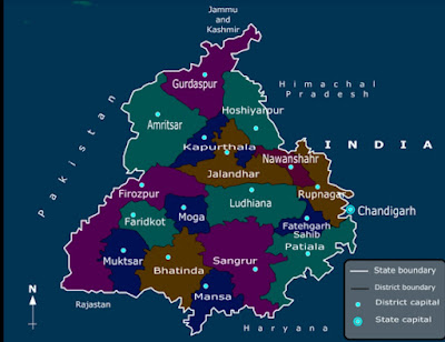
~THE PUNJAB has a geographical unity distinct from the neighbouring countries and
~the rest of India. It is shaped like a scalene
triangle balanced on its sharpest angle. The shortest side
is in the north and is composed of the massive Himalayas,
which separate it from the Tibetan plateau.
The western
side is bounded by the river Indus from the point it enters
the plains to another point 1,650 miles downstream, where
it meets the confluence of the Punjab's rivers at a place
appropriately named panjnad, the five streams. Westwards
of the Indus runs a chain of rugged mountains, the Hindu
Kush and the Sulaiman, pierced by several passes like the
Khyber and the Bolan which have served as inlets for the
people of the countries which lie beyond, Afghanistan and
Baluchistan. The eastern boundary of the Punjab's tri-
angle is not clearly marked, but from a point near Karnal
where the Jumna plunges southeastwards a jagged line can
be drawn up to Panjnad, which will demarcate the state
from the rest of Hindustan and the Sindh desert.
The Punjab, except for the salt range in its centce, is
an extensive plain sloping gently down from the moun-
tains in the north and the west towards the desert in the
south. Across this monotonously flat land flow six large
rivers: the Indus, Jhelum, Chenab, Ravi, Beas, and the Sut-
lej. In the intra-fluvial tracts or doabs1 between these rivers
1 The intra-fluvial tracts or mesopotamias are known in the Punjab as
dollbs-two waters. Except for the doabs between the Indus and the
Jhelum and the Sutlej and the Jumna, they are known by a combination
of the names of the two rivers between which they lie. These names were
roined in the time of Emperor Akbar, presumably by his minister, Todar
Mal.
a. The Sindh Sagar Doab, between the Indus and the Jhelum.
b. The Chaj Doab between the Chenab and the Jhelum. This doab was
.ti!IO known as Dhanni-Gheb, Chinhat-Chenab, and Behat (which is an-
nther name for the Jhelum).
. 3 •


No comments:
Post a Comment